


wallon de la meije

oliviergau
User
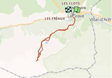

Length
15.5 km

Max alt
3195 m

Uphill gradient
1774 m
Km-Effort
39 km

Min alt
1430 m

Downhill gradient
1774 m
Boucle
Yes
Creation date :
2021-03-08 07:48:14.293
Updated on :
2021-03-08 14:07:50.107
4h50
Difficulty : Very easy

FREE GPS app for hiking
 SityTrail
IGN / Geographical institutes
SityTrail Plus
The world is yours!
About
Trail Touring skiing of 15.5 km to be discovered at Provence-Alpes-Côte d'Azur, Hautes-Alpes, La Grave. This trail is proposed by oliviergau.
Positioning
Country:
France
Region :
Provence-Alpes-Côte d'Azur
Department/Province :
Hautes-Alpes
Municipality :
La Grave
Location:
Unknown
Start:(Dec)
Start:(UTM)
287634 ; 4991454 (32T) N.
Comments